


Col du Chat - Col de l'épine - Mont du Chat

PhilippeC54
User
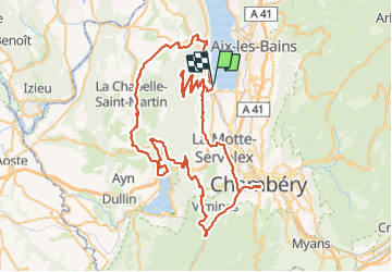

Length
106 km

Max alt
1495 m

Uphill gradient
2972 m
Km-Effort
146 km

Min alt
232 m

Downhill gradient
2973 m
Boucle
Yes
Creation date :
2021-10-01 07:38:05.41
Updated on :
2021-10-01 15:15:23.652
6h21
Difficulty : Very difficult

FREE GPS app for hiking
 SityTrail
IGN / Geographical institutes
SityTrail Plus
The world is yours!
About
Trail Road bike of 106 km to be discovered at Auvergne-Rhône-Alpes, Savoy, Le Bourget-du-Lac. This trail is proposed by PhilippeC54.
Positioning
Country:
France
Region :
Auvergne-Rhône-Alpes
Department/Province :
Savoy
Municipality :
Le Bourget-du-Lac
Location:
Unknown
Start:(Dec)
Start:(UTM)
723043 ; 5059504 (31T) N.
Comments